New York Nearest Subway: The Easiest Way To Travel This Island Without A Map
App Type: iPhone

Our rating: 


By: acrossair
Version #: 1.0
Date Released:
Developer:
Price: 1.99
User Rating:


The New York subway system is a remarkably convenient and affordable way to travel throughout the city, but the problem is that it is often confusing to know which entrance to use and which trains will arrive in the station. Now, anyone using the New York Nearest Subway app will be able to see the nearest stations as well as the trains that are entering and exiting them on a regular basis.
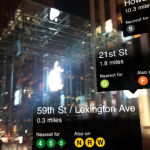
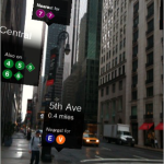
Those using the New York Nearest Subway app will not have to figure out the standard two-dimensional map, and will instead receive a photographic image of their location with the various subway terminals pictured in the direction in which they are located. The terminal information provided includes the number of miles to the station, and the nearest trains that will take the individual to their destination. For instance, they might see a sign that says 59th Street and also that it is the nearest station for the 4, 5, 6, N, R, and W trains.
There are other subway and New York navigational maps, but the New York Nearest Subway aims to be more user-friendly and easy to read than any others. This app functions exclusively with iPhone 3G accounts, and operates with English, French, German, Spanish and Japanese Languages.
The cost for the New York Nearest Subway app is $1.99 and any updates are free of charge.
If you want a visually pleasing way to understand and navigate the NYC subway system, this is the app for you to download today.



 navigation